


GPS_GT_VTT_Creuse_Vdef2

topolino
User
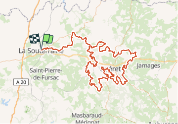

Length
263 km

Max alt
684 m

Uphill gradient
5403 m
Km-Effort
335 km

Min alt
304 m

Downhill gradient
5403 m
Boucle
Yes
Creation date :
2021-06-04 11:25:38.763
Updated on :
2021-06-04 11:26:29.805
--
Difficulty : Unknown

FREE GPS app for hiking
 SityTrail
IGN / Geographical institutes
SityTrail Plus
The world is yours!
About
Trail Mountain bike of 263 km to be discovered at New Aquitaine, Creuse, La Souterraine. This trail is proposed by topolino.
Positioning
Country:
France
Region :
New Aquitaine
Department/Province :
Creuse
Municipality :
La Souterraine
Location:
Unknown
Start:(Dec)
Start:(UTM)
383680 ; 5121803 (31T) N.
Comments